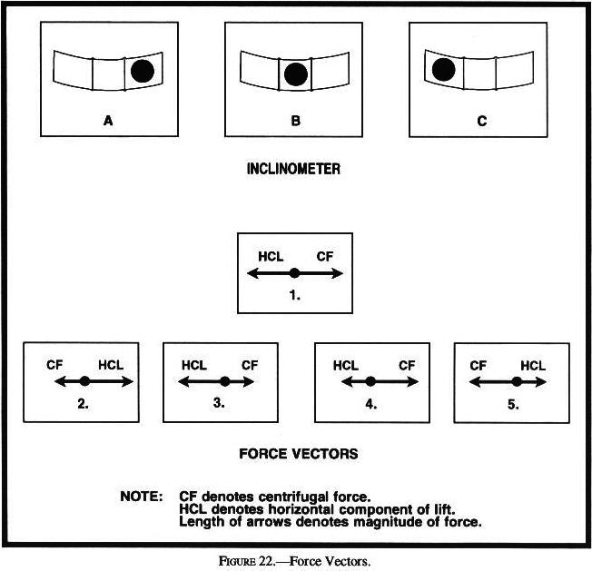
Answer B is Incorrect, Try Again
![]()
Answer B is Incorrect, Try Again
![]()
Answer C is Incorrect, Try Again
| Each Federal airway includes that airspace extending upward from 1,200 feet above the surface of the earth to, but not including, 18,000 feet MSL, except that Federal airways for Hawaii have no upper limits. |
| no person may operate an aircraft ... under VFR within the lateral boundaries of ... an airport when the ceiling is less than 1,000 feet. ... no person may take off or land an aircraft ... under VFR, within ... the surface areas of Class B, Class C, Class D, or Class E airspace designated for an airport-- Unless ground visibility at that airport is at least 3 statute miles. |
| Each Federal airway includes the airspace within parallel boundary lines 4 miles each side of the center line. |
| Each person must establish two-way radio communications with the ATC facility ... providing air traffic services prior to entering that airspace and thereafter maintain those communications while within that airspace. |
| Departures. Each pilot of an aircraft must comply with any traffic patterns established for that airport in part 93 of this chapter. |
| During the hours the tower is not in operation, the Class E surface area rules or a combination of Class E rules to 700 ft AGL and Class G rules to the surface will become applicable. |
| Class D airspace areas are depicted on Sectional and Terminal charts with blue segmented lines. |
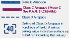
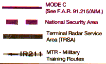
| no person may operate an aircraft within a Class C airspace area designated for an airport unless that aircraft is equipped with the applicable equipment specified in Sec. 91.215 (transponder having 4096 code capability and Mode C pressure altitude reporting capability). |
| No person may operate an aircraft so close to another aircraft as to create a collision hazard. No person may operate an aircraft in formation flight except by arrangement with the pilot in command of each aircraft in the formation. No person may operate an aircraft, carrying passengers for hire, in formation flight. |
| If the aircraft are of different categories-- A balloon has the right-of-way over any other category of aircraft; A glider has the right-of-way over an airship, airplane, or rotorcraft; and An airship has the right-of-way over an airplane or rotorcraft. However, an aircraft towing or refueling other aircraft has the right-of-way over all other engine-driven aircraft. |
| When aircraft of the same category are converging at approximately the same altitude (except head-on, or nearly so), the aircraft to the other's right has the right-of-way. |
| ... no person may operate an aircraft to, from, through, or on an airport having an operational control tower unless two-way radio communications are maintained between that aircraft and the control tower. Communications must be established prior to 4 nautical miles from the airport, up to and including 2,500 feet AGL. |
| An aircraft in distress has the right-of-way over all other air traffic. |
| Basic VFR weather minimums. Class C; D; and E (<10,000 ft MSL) - 3 statute miles; 500 feet below; 1,000 feet above; 2,000 feet horizontal. |
| Basic VFR weather minimums. Class G: (1,200 feet or less AGL) Day - 1 statute mile; Clear of clouds. Night - 3 statute miles; 500 feet below; 1,000 feet above; 2,000 feet horizontal. |
| Basic VFR weather minimums. Class C; D; and E (<10,000 ft MSL) - 3 statute miles; 500 feet below; 1,000 feet above; 2,000 feet horizontal. |
| Basic VFR weather minimums. Class C; D; and E (<10,000 ft MSL) - 3 statute miles; 500 feet below; 1,000 feet above; 2,000 feet horizontal. |
| Basic VFR weather minimums. Class G: (>1,200 ft AGL but <10,000 ft MSL) Day - 1 statute mile; 500 feet below; 1,000 feet above; 2,000 feet horizontal. Night - 3 statute miles; 500 feet below; 1,000 feet above; 2,000 feet horizontal. |
| no person may operate an aircraft ... under VFR within the lateral boundaries of ... an airport when the ceiling is less than 1,000 feet. ... no person may take off or land an aircraft ... under VFR, within ... the surface areas of Class B, Class C, Class D, or Class E airspace designated for an airport-- Unless ground visibility at that airport is at least 3 statute miles. |
| The pilot can contribute to collision avoidance by being alert and scanning for other aircraft. |
|
|
|
|
|
|
|
|
| For runways and taxiways which are permanently closed, the lighting circuits will be disconnected. The runway threshold, runway designation, and touchdown markings are obliterated and yellow crosses are placed at each end of the runway and at 1,000 foot intervals. |
| The portion of the runway behind a displaced threshold is available for takeoffs in either direction and landings from the opposite direction. White arrows are located along the centerline in the area between the beginning of the runway and the displaced threshold. A demarcation bar delineates a runway with a displaced threshold from a blast pad, stopway or taxiway that precedes the runway. Chevrons are used to show pavement areas aligned with the runway that are unusable for landing, takeoff, and taxiing. Chevrons are yellow. |
| The portion of the runway behind a displaced threshold is available for takeoffs in either direction and landings from the opposite direction. White arrows are located along the centerline in the area between the beginning of the runway and the displaced threshold. A demarcation bar delineates a runway with a displaced threshold from a blast pad, stopway or taxiway that precedes the runway. Chevrons are used to show pavement areas aligned with the runway that are unusable for landing, takeoff, and taxiing. Chevrons are yellow. |
| The portion of the runway behind a displaced threshold is available for takeoffs in either direction and landings from the opposite direction. White arrows are located along the centerline in the area between the beginning of the runway and the displaced threshold. A demarcation bar delineates a runway with a displaced threshold from a blast pad, stopway or taxiway that precedes the runway. Chevrons are used to show pavement areas aligned with the runway that are unusable for landing, takeoff, and taxiing. Chevrons are yellow. |
| The runway number is the whole number nearest one-tenth the magnetic azimuth of the centerline of the runway,...letters differentiate between left (L), right (R), or center (C), parallel runways. |
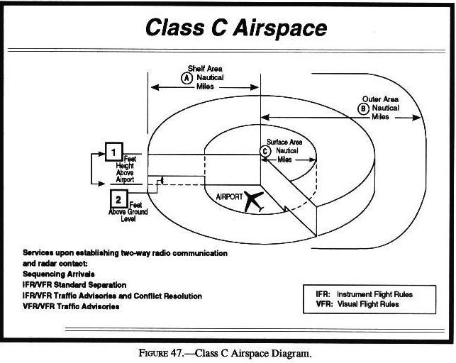
 Also applicable to Class C airspace. Also applicable to Class C airspace.
|
|
Also applicable to Class C airspace.
|
| Two-way radio communication must be established with the ATC facility providing ATC services prior to entry and thereafter maintain those communications while in Class C airspace. |
| Outer Area: The normal radius will be 20 NM, with some variations based on site specific requirements. |
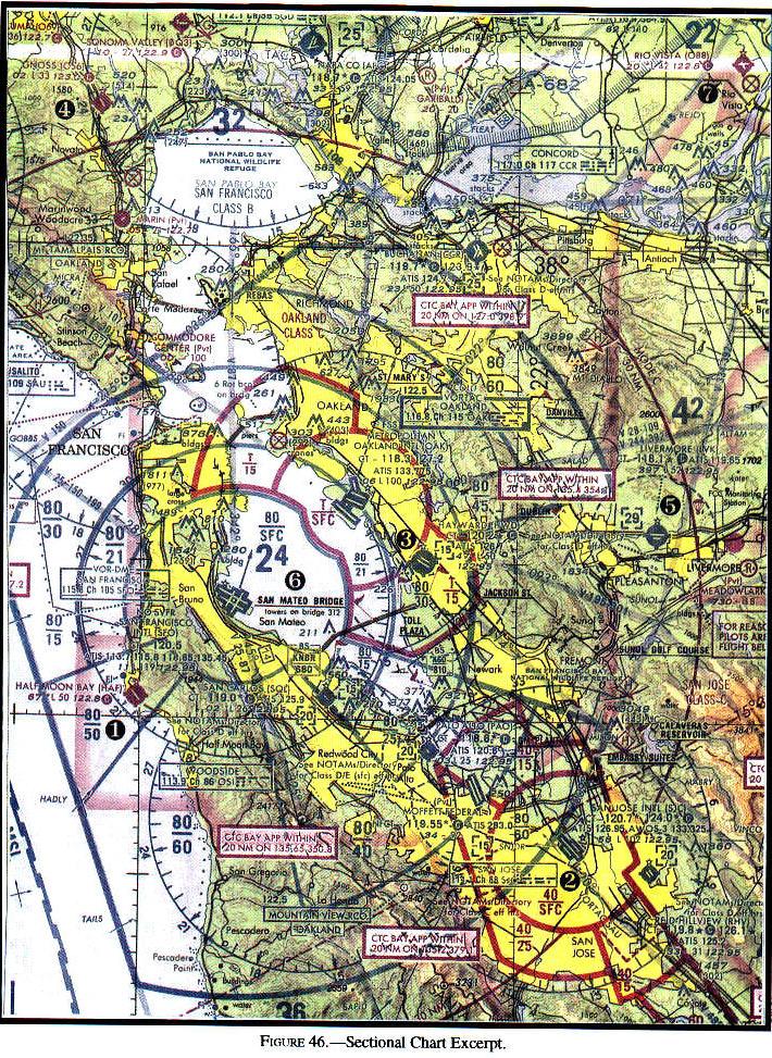
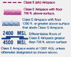
| Class C airspace...usually consists of a 5 NM radius core surface area that extends from the surface up to 4,000 feet above the airport elevation, and a 10 NM radius shelf area that extends from 1,200 feet to 4,000 feet above the airport elevation. |
| Class D Airspace Definition: Generally, that airspace from the surface to 2,500 feet above the airport elevation (charted in MSL) surrounding those airports that have an operational control tower. The configuration of each Class D airspace area is individually tailored and when instrument procedures are published, the airspace will normally be designed to contain the procedures. |
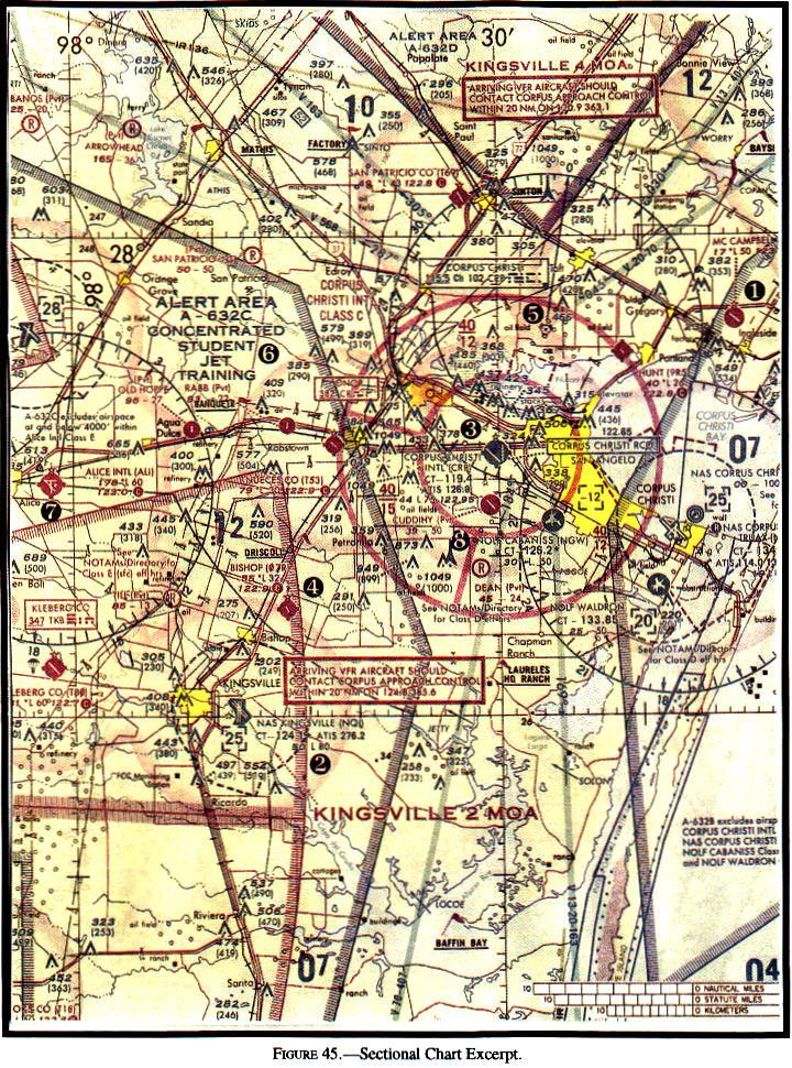
| Alert areas are depicted on aeronautical charts to inform nonparticipating pilots of areas that may contain a high volume of pilot training or an unusual type of aerial activity. All activity within an alert area shall be conducted in accordance with CFRs, without waiver, and pilots of participating aircraft as well as pilots transiting the area shall be equally responsible for collision avoidance. |
| Most training activities necessitate acrobatic or abrupt flight maneuvers. |
| Restricted areas denote the existence of unusual, often invisible, hazards to aircraft such as artillery firing, aerial gunnery, or guided missiles. Penetration of restricted areas without authorization from the using or controlling agency may be extremely hazardous to the aircraft or its occupants. |
| Pilots operating under VFR should exercise extreme caution while flying within a MOA when military activity is being conducted. Prior to entering an active MOA, pilots should contact the controlling agency for traffic advisories. |
| Restricted areas denote the existence of unusual, often invisible, hazards to aircraft such as artillery firing, aerial gunnery, or guided missiles. Penetration of restricted areas without authorization from the using or controlling agency may be extremely hazardous to the aircraft or its occupants. |
| MTRs with no segment above 1,500 feet AGL shall be identified by four number characters. MTRs that include one or more segments above 1,500 feet AGL shall be identified by three number characters. |
|
|
|
|
|
|
|
|
|
| Two-way radio communication must be established with the ATC facility providing ATC services prior to entry and thereafter maintain those communications while in Class C airspace. |
|
|
|
|
|
|
|
|
|
| During climbs and descents in flight conditions which permit visual detection of other traffic, pilots should execute gentle banks, left and right at a frequency which permits continuous visual scanning of the airspace about them. |
| Effective scanning is accomplished with a series of short, regularly spaced eye movements that bring successive areas of the sky into the central visual field. Each movement should not exceed 10 degrees, and each area should be observed for at least 1 second to enable detection. |
| Effective scanning is accomplished with a series of short, regularly spaced eye movements that bring successive areas of the sky into the central visual field. Each movement should not exceed 10 degrees, and each area should be observed for at least 1 second to enable detection. |
| Any aircraft that appears to have no relative motion and stays in one scan quadrant is likely to be on a collision course. Also, if a target shows no lateral or vertical motion, but increases in size, take evasive action. |
| Remarks-Data is confined to operational items affecting the status and usability of the airport. Parachute Jumping - See "PARACHUTE" tabulation for details. |
|
Also applicable to Class C airspace.
|
| Federal Airways: The Federal airways are Class E airspace areas and, unless otherwise specified, extend upward from 1,200 feet to, but not including, 18,000 feet MSL. |
|
|

|
|
|
|
|
| Class C Equipment:(a) Two-way radio, and (b) Unless otherwise authorized by ATC, an operable radar beacon transponder with automatic altitude reporting equipment. |
|
|
|
|
| Class E Less than 10,000 feet MSL: 3 statute miles; 500 feet below, 1,000 feet above, 2,000 feet horizontal. |
| Class G 1,200 feet or less above the surface (regardless of MSL altitude). Day: 1 statute mile, Clear of clouds. |
| Each Federal airway includes that airspace extending upward from 1,200 feet above the surface of the earth to, but not including, 18,000 feet MSL, except that Federal airways for Hawaii have no upper limits. |
| When approaching to land at an airport without an operating control tower in Class G airspace-- Each pilot of an airplane must make all turns of that airplane to the left unless the airport displays approved light signals or visual markings indicating that turns should be made to the right. |
| No person may operate an aircraft within a Class B airspace area except ... The operator must receive an ATC clearance from the ATC facility having jurisdiction for that area before operating an aircraft in that area. |
| No person may take off or land a civil aircraft at an airport within a Class B airspace area or operate a civil aircraft within a Class B airspace area unless-- The pilot in command holds at least a private pilot certificate; or ... a student pilot or recreational pilot who ... has met the requirements of Sec. 61.95 of this chapter. |
| ... no person may operate an aircraft to, from, through, or on an airport having an operational control tower unless two-way radio communications are maintained between that aircraft and the control tower. Communications must be established prior to 4 nautical miles from the airport, up to and including 2,500 feet AGL. |
| No person may operate an aircraft so close to another aircraft as to create a collision hazard. No person may operate an aircraft in formation flight except by arrangement with the pilot in command of each aircraft in the formation. No person may operate an aircraft, carrying passengers for hire, in formation flight. |
| When two or more aircraft are approaching an airport for the purpose of landing, the aircraft at the lower altitude has the right-of-way, but it shall not take advantage of this rule to cut in front of another which is on final approach to land or to overtake that aircraft. |
| No person may operate an aircraft so close to another aircraft as to create a collision hazard. No person may operate an aircraft in formation flight except by arrangement with the pilot in command of each aircraft in the formation. No person may operate an aircraft, carrying passengers for hire, in formation flight. |
| Basic VFR weather minimums. Class G: (>1,200 ft AGL and at or above 10,000 ft MSL) - 5 statute miles; 1,000 feet below; 1,000 feet above; 1 statute mile horizontal. |
| Basic VFR weather minimums. Class C; D; and E (<10,000 ft MSL) - 3 statute miles; 500 feet below; 1,000 feet above; 2,000 feet horizontal. |
| Basic VFR weather minimums. Class G: (>1,200 ft AGL and at or above 10,000 ft MSL) - 5 statute miles; 1,000 feet below; 1,000 feet above; 1 statute mile horizontal. |
| Each person operating an aircraft in Class D airspace must ... establish two-way radio communications with the ATC facility providing air traffic services prior to entering that airspace and thereafter maintain those communications while within that airspace. |
| No person may operate an aircraft so close to another aircraft as to create a collision hazard. No person may operate an aircraft in formation flight except by arrangement with the pilot in command of each aircraft in the formation. No person may operate an aircraft, carrying passengers for hire, in formation flight. |
| Unless otherwise authorized by ATC, no person may operate an aircraft within Class A airspace unless that aircraft is equipped with the applicable equipment specified in Sec. 91.215 (transponder having 4096 code capability and Mode C pressure altitude reporting capability). |
| Except as provided in paragraph (d) of this section, each person operating an aircraft in Class A airspace must conduct that operation under instrument flight rules (IFR) |
 No Entry Sign: This sign prohibits an aircraft from entering an area. Typically, this sign would be located on a taxiway intended to be used in only one direction or at the intersection of vehicle roadways with runways, taxiways or aprons where the roadway may be mistaken as a taxiway. No Entry Sign: This sign prohibits an aircraft from entering an area. Typically, this sign would be located on a taxiway intended to be used in only one direction or at the intersection of vehicle roadways with runways, taxiways or aprons where the roadway may be mistaken as a taxiway.
|
 Runway Boundary Sign: This sign has a yellow background with a black inscription with a graphic depicting the pavement holding position marking... The sign is intended to provide pilots with another visual clue which they can use as a guide in deciding when they are "clear of the runway." Runway Boundary Sign: This sign has a yellow background with a black inscription with a graphic depicting the pavement holding position marking... The sign is intended to provide pilots with another visual clue which they can use as a guide in deciding when they are "clear of the runway."
|
| Class G 1,200 feet or less above the surface (regardless of MSL altitude). Day: 1 statute mile, Clear of clouds. |
|
|
| Alert areas are depicted on aeronautical charts to inform nonparticipating pilots of areas that may contain a high volume of pilot training or an unusual type of aerial activity. All activity within an alert area shall be conducted in accordance with CFRs, without waiver, and pilots of participating aircraft as well as pilots transiting the area shall be equally responsible for collision avoidance. |

|
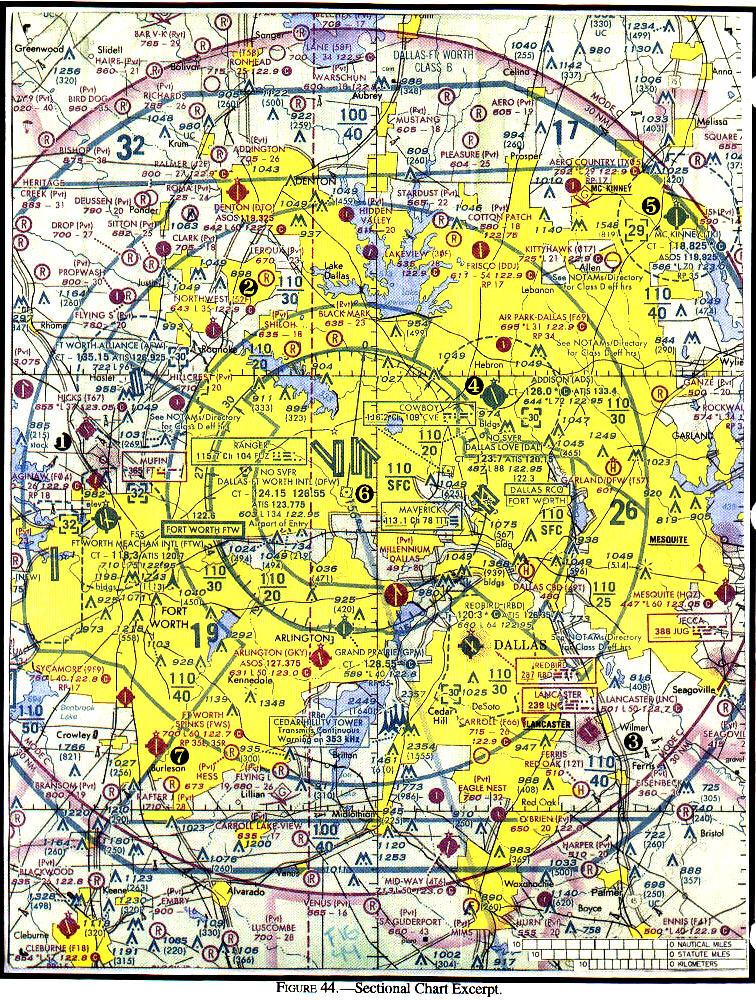
| Airports having Control Towers are shown in Blue, all others in Magenta. |
|
| When overlapping airspace designations apply to the same airspace, the operating rules associated with the more restrictive airspace designation apply. |
|
|
| an aircraft that was not originally certificated with an engine-driven electrical system or which has not subsequently been certified with a system installed may conduct operations within a Mode C veil provided the aircraft remains outside Class A, B or C airspace; and below the altitude of the ceiling of a Class B or Class C airspace area designated for an airport or 10,000 feet MSL, whichever is lower. |
|
|
|
|
|
|
|
|
| Any aircraft that appears to have no relative motion and stays in one scan quadrant is likely to be on a collision course. Also, if a target shows no lateral or vertical motion, but increases in size, take evasive action. |
| A student pilot may not operate an aircraft on a solo flight in Class B airspace unless: (1) The student pilot has received both ground and flight training from an authorized instructor on that Class B airspace area, ... (2) The logbook of that student pilot has been endorsed by the authorized instructor who gave the student pilot flight training, and the endorsement is dated within the 90-day period preceding the date of the flight in that Class B airspace area. |
| Departures. Each pilot of an aircraft must comply with any traffic patterns established for that airport in part 93 of this chapter. |
| Notwithstanding the provisions of paragraph (b)(1)(ii) of this section, no person may take off or land a civil aircraft at those airports listed in section 4 of appendix D of this part unless the pilot in command holds at least a private pilot certificate. |
| Basic VFR weather minimums. Class E: At or above 10,000 feet MSL - 5 statute miles; 1,000 feet below; 1,000 feet above; 1 statute mile. |
| Class D Airspace - Generally, that airspace from the surface to 2,500 feet above the airport elevation surrounding those airports that have an operating control tower. |
| Basic VFR weather minimums. Class B - 3 statute miles; Clear of Clouds. |
| ... no person may operate an aircraft ...unless that aircraft is equipped with automatic pressure altitude reporting equipment having Mode C capability ... in all airspace above the ceiling and within the lateral boundaries of a Class B or Class C airspace area designated for an airport upward to 10,000 feet MSL. |
 Runway Holding Position Sign: This sign is located at the holding position on taxiways that intersect a runway or on runways that intersect other runways. Runway Holding Position Sign: This sign is located at the holding position on taxiways that intersect a runway or on runways that intersect other runways.
|
|
No Entry Sign: This sign prohibits an aircraft from entering an area. Typically, this sign would be located on a taxiway intended to be used in only one direction or at the intersection of vehicle roadways with runways, taxiways or aprons where the roadway may be mistaken as a taxiway.
|
 DIRECTION SIGNS Direction signs are normally located on the left prior to the intersection. When used on a runway to indicate an exit, the sign is located on the same side of the runway as the exit. DIRECTION SIGNS Direction signs are normally located on the left prior to the intersection. When used on a runway to indicate an exit, the sign is located on the same side of the runway as the exit.
|
| The portion of the runway behind a displaced threshold is available for takeoffs in either direction and landings from the opposite direction. White arrows are located along the centerline in the area between the beginning of the runway and the displaced threshold. A demarcation bar delineates a runway with a displaced threshold from a blast pad, stopway or taxiway that precedes the runway. Chevrons are used to show pavement areas aligned with the runway that are unusable for landing, takeoff, and taxiing. Chevrons are yellow. |
| The runway number is the whole number nearest one-tenth the magnetic azimuth of the centerline of the runway,...letters differentiate between left (L), right (R), or center (C), parallel runways. |
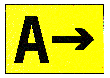
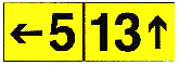 DESTINATION SIGNS Destination signs also have a yellow background with a black inscription indicating a destination on the airport. These signs always have an arrow showing the direction of the taxiing route to that destination. DESTINATION SIGNS Destination signs also have a yellow background with a black inscription indicating a destination on the airport. These signs always have an arrow showing the direction of the taxiing route to that destination.
|
| The portion of the runway behind a displaced threshold is available for takeoffs in either direction and landings from the opposite direction. White arrows are located along the centerline in the area between the beginning of the runway and the displaced threshold. A demarcation bar delineates a runway with a displaced threshold from a blast pad, stopway or taxiway that precedes the runway. Chevrons are used to show pavement areas aligned with the runway that are unusable for landing, takeoff, and taxiing. Chevrons are yellow. |
| Class A Airspace Definition: Generally, that airspace from 18,000 feet MSL up to and including FL600. |
| Class C airspace...usually consists of a 5 NM radius core surface area that extends from the surface up to 4,000 feet above the airport elevation, and a 10 NM radius shelf area that extends from 1,200 feet to 4,000 feet above the airport elevation. |
| Class C airspace...usually consists of a 5 NM radius core surface area that extends from the surface up to 4,000 feet above the airport elevation, and a 10 NM radius shelf area that extends from 1,200 feet to 4,000 feet above the airport elevation. |
| Class D Airspace Definition: Generally, that airspace from the surface to 2,500 feet above the airport elevation (charted in MSL) surrounding those airports that have an operational control tower. The configuration of each Class D airspace area is individually tailored and when instrument procedures are published, the airspace will normally be designed to contain the procedures. |
| Unless designated at a lower altitude, Class E airspace begins at 14,500 feet MSL to, but not including 18,000 feet MSL. |
|
Also applicable to Class C airspace.
|
| Class C Equipment:(a) Two-way radio, and (b) Unless otherwise authorized by ATC, an operable radar beacon transponder with automatic altitude reporting equipment. |
| During the hours the tower is not in operation, the Class E surface area rules or a combination of Class E rules to 700 feet AGL and Class G rules to the surface will become applicable. |
| Restricted areas denote the existence of unusual, often invisible, hazards to aircraft such as artillery firing, aerial gunnery, or guided missiles. Penetration of restricted areas without authorization from the using or controlling agency may be extremely hazardous to the aircraft or its occupants. |
| Pilots operating under VFR should exercise extreme caution while flying within a MOA when military activity is being conducted. Prior to entering an active MOA, pilots should contact the controlling agency for traffic advisories. |
| Alert areas are depicted on aeronautical charts to inform nonparticipating pilots of areas that may contain a high volume of pilot training or an unusual type of aerial activity. All activity within an alert area shall be conducted in accordance with CFRs, without waiver, and pilots of participating aircraft as well as pilots transiting the area shall be equally responsible for collision avoidance. |
| The airport advisory area is the area within 10 statute miles of an airport where a control tower is not operating but where a FSS is located. At such locations, the FSS provides advisory service to arriving and departing aircraft. |
| Mode C Veil: The airspace within 30 NM of ... primary airports within Class B airspace areas, from the surface upward to 10,000 feet MSL. Unless otherwise authorized ... aircraft operating within this airspace must be equipped with automatic pressure altitude reporting equipment having Mode C capability. |
|
|
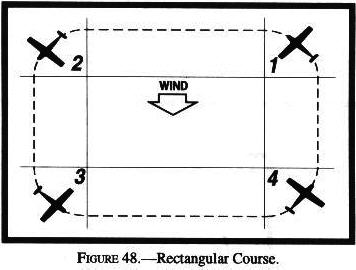
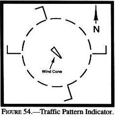
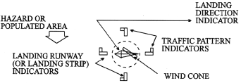
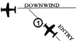 1 - Enter pattern in level flight abeam the midpoint of the runway, at pattern altitude. 1 - Enter pattern in level flight abeam the midpoint of the runway, at pattern altitude.
|
| Effective scanning is accomplished with a series of short, regularly spaced eye movements that bring successive areas of the sky into the central visual field. Each movement should not exceed 10 degrees, and each area should be observed for at least 1 second to enable detection. |
| Remarks-Data is confined to operational items affecting the status and usability of the airport. Parachute Jumping - See "PARACHUTE" tabulation for details. |
| Remember, most collisions occur during days when the weather is good. |