Most glider pilots had a lot of experience as land animals, living at the bottom of a sea of air before we learned to fly in it. As such our perception of the atmosphere was somewhat distorted; we recognized horizontal movement of air, which we called "wind", but had little appreciation for its vertical movement. Since a glider (with rare exceptions) is always descending through the air in which it flies, the only way to go up (or avoid coming down) is to fly in air that is rising fast enough to offset our descent rate within it. Thus glider pilots have a great interest in vertical air movement.
The portion of the atmosphere we will be discussing is called the troposphere. It is where most weather occurs. The next layer above is called the stratosphere, and if you plan to fly your glider there you need another reference source. The boundary between the troposphere and the stratosphere is called the tropopause.
The atmosphere is made up of a mixture of gasses with a few things like Dorothy's house sometimes carried about by them. Dry air is 78% nitrogen, 21% oxygen, and the remaining 1% a mixture of other gasses. The ratio of gasses is essentially constant at all locations and all altitudes. Air sometimes contains moisture in the form of water vapor in amounts less than 5%. When it does, the other gasses decrease proportionately.
|
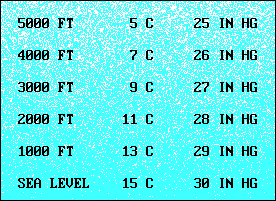
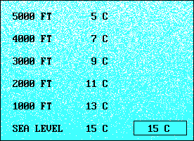
| Although the composition of air doesn't change with altitude, its temperature and pressure do. In general, both decrease with altitude, but the rate of decrease can vary, so something called the "standard atmosphere" was created to provide a reference point for actual observations. The sea level standard is: Pressure 29.92 in. Hg or 1013.2 millibars, Temperature 15.0oC or 59oF. For our purposes, we can assume that pressure decreases one inch of mercury (Hg) per 1,000 feet, and temperature decreases two degrees Celsius (C) per 1,000 feet. We refer to these rates of change as "lapse rates". They are reasonable estimates for use in the troposphere, but the temperature lapse rate changes abruptly at the tropopause. |
Since air is a compressible gas its density decreases as the atmospheric pressure decreases with an increase in altitude. Density also decreases as temperature increases; a change of 8 degrees C changes air density about as much as an altitude change of 1,000 feet. The term "Density Altitude" refers to the altitude under standard conditions of pressure and temperature that would exhibit the same density as that produced by the existing pressure and temperature. Aircraft performance is significantly affected by density altitude and pilots need to know how to compute it with reasonable accuracy.
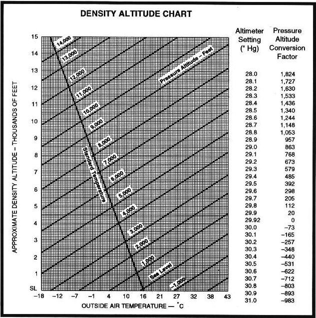
The Density Altitude Chart can be used to determine density altitude from pressure altitude and temperature. Find the intersection of the vertical temperature line and the sloping pressure altitude line. Then move horizontally to read density altitude at the left side of the chart. Pressure altitude can be found by adding the pressure altitude conversion factor for the current altimeter setting to indicated altitude.
Note the Standard Temperature line that crosses the intersections where Pressure Altitude and Density Altitude are equal. That's what you would expect in the Standard Atmosphere. You can see from this chart that, if the temperature is 8oC above standard, the density altitude is about 1,000 feet higher.
There are three temperature lapse rates with which the glider pilot should be familiar. The "Standard Lapse Rate" of two degrees C per thousand feet is a kind of worldwide average and serves only as a standard of comparison. The "Actual Lapse Rate" is whatever exits at a particular place and time and it determines whether soaring will be fun or impossible at that place and time.
 The third is the "Dry Adiabatic Lapse Rate" (dry in this case means that the temperature exceeds the dew point, so if you are not flying in clouds it applies). It is the rate of change of temperature of dry air that is lifted and it is approximately 3 degrees C per 1,000 feet. That means that if you could capture a parcel of air at a temperature of 15oC and raise it 5,000 feet, it would cool to 0oC
[15 - (3 x 5) = 0].
The third is the "Dry Adiabatic Lapse Rate" (dry in this case means that the temperature exceeds the dew point, so if you are not flying in clouds it applies). It is the rate of change of temperature of dry air that is lifted and it is approximately 3 degrees C per 1,000 feet. That means that if you could capture a parcel of air at a temperature of 15oC and raise it 5,000 feet, it would cool to 0oC
[15 - (3 x 5) = 0].
If in this example the air through which we raised the parcel had a standard lapse rate, the temperature outside the parcel at the new altitude would be 5oC [15 - (2 x 5) = 5], 5oC warmer than the lifted parcel. If we then released the parcel it would sink back to its original position because it is colder than the surrounding air. (Actually it sinks because it is denser, but it is denser because it is colder. Anyway, most people are comfortable with the idea that warm air rises and cold air sinks.)
We have just explained why "standard" air is stable. "Stable", whether applied to air or gliders, means that, if disturbed, it will return to its original condition. It is easy to see why stable air generally is not good for flying gliders. We want air to keep going up, not start back down.
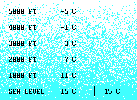 If the actual lapse rate in our example had been
4oC per 1,000 feet, the temperature at 5,000 feet would have been -5oC [15 - (4 x 5) = -5] and our parcel would have been warmer and would have continued to rise without our help. This is an example of unstable air. Generally, the atmosphere is considered unstable if the temperatures aloft are significantly colder than at the surface. Anything that causes the air to be heated at the surface, such as cool air moving over a warm surface, will cause the air to be less stable. If colder air aloft moves in over warmer air below, that too decreases stability. On the other hand, warm air moving over a cool surface or warm air moving in aloft increases stability.
If the actual lapse rate in our example had been
4oC per 1,000 feet, the temperature at 5,000 feet would have been -5oC [15 - (4 x 5) = -5] and our parcel would have been warmer and would have continued to rise without our help. This is an example of unstable air. Generally, the atmosphere is considered unstable if the temperatures aloft are significantly colder than at the surface. Anything that causes the air to be heated at the surface, such as cool air moving over a warm surface, will cause the air to be less stable. If colder air aloft moves in over warmer air below, that too decreases stability. On the other hand, warm air moving over a cool surface or warm air moving in aloft increases stability.
Often on a clear night with light winds, the earth radiates heat and the air near the surface becomes cooler than air above. The lapse rate in this case is inverted, temperature increases with altitude. The name for this condition is an "inversion". Inversions can also exist at higher altitudes, and the air in any inversion is very stable. "A ground based inversion favors poor visibility by trapping fog, smoke, and other restrictions into low levels of the atmosphere." (2)
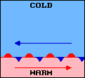
The vertical motion of the air we are describing here is called "convection". Thermals are relatively small-scale versions of convection. They are the result of surface heating, usually from the sun, and occur most often on summer afternoons when winds are light. Although we usually think of warm air as rising, it is actually forced up by cooler, denser air sinking between thermals. The total amount of air going up must equal the amount coming down. Fast rising thermals usually occupy a small percent of a convective area, while slower downdrafts occupy the rest.
On a much larger scale, the distribution of solar energy around the world causes wide differences in temperature at different locations. "Differences in temperature create differences in pressure. These pressure differences drive a complex system of winds in a never ending attempt to reach equilibrium." (2) These pressure differences appear as highs and lows. Highs and ridges are areas of descending air, usually associated with good weather. A low or trough is an area of rising air, usually associated with bad weather. Weather charts show pressure differences by lines of equal pressure, called isobars. They are analogous to contour lines on a surface map. Highs are like hills and lows are like valleys, but air is less viscous than dirt so the highs are always trying to flow into the lows. The spacing of isobars indicates the strength of the pressure difference, referred to as a "pressure gradient". Close spacing indicates a strong gradient and strong winds.
 The pressure difference drives air from a high to a low, but its path
is not direct. Coriolis force is the result of the rotation of the
earth and it acts on everything that moves. The circumference of the earth
is about 24,000 miles. Since it rotates once every 24 hours, any point
at the equator is moving east at about 1,000 MPH. Anything at the north
pole, however, is just rotating and not moving east at all. If a parcel of air
at the equator starts moving north it is moving over a surface that is
moving at a slower and slower rate, relative to the parcel. To an observer on the surface
the air would be deflected to the east or turning right. Similarly, a parcel of air
starting at a latitude of 60o where its eastward velocity
is about 500 MPH, and moving south, is traveling over a surface that is
moving to the east at a faster rate. To a surface observer the parcel would
be turning west, again to the right. In the Southern Hemisphere, the turns
would be to the left.
The pressure difference drives air from a high to a low, but its path
is not direct. Coriolis force is the result of the rotation of the
earth and it acts on everything that moves. The circumference of the earth
is about 24,000 miles. Since it rotates once every 24 hours, any point
at the equator is moving east at about 1,000 MPH. Anything at the north
pole, however, is just rotating and not moving east at all. If a parcel of air
at the equator starts moving north it is moving over a surface that is
moving at a slower and slower rate, relative to the parcel. To an observer on the surface
the air would be deflected to the east or turning right. Similarly, a parcel of air
starting at a latitude of 60o where its eastward velocity
is about 500 MPH, and moving south, is traveling over a surface that is
moving to the east at a faster rate. To a surface observer the parcel would
be turning west, again to the right. In the Southern Hemisphere, the turns
would be to the left.
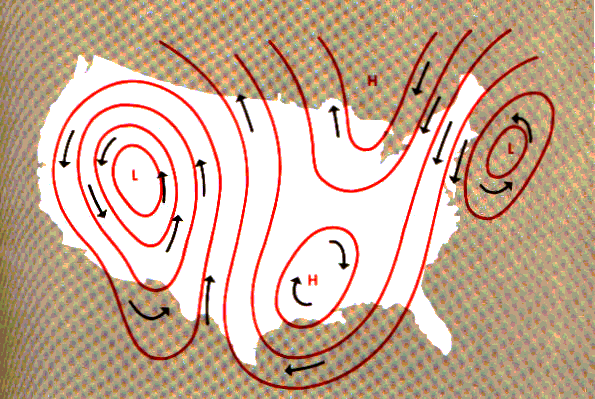 We call horizontally
moving air "wind", and soon it is blowing parallel to the isobars.
Coriolis then is balanced by the pressure difference that caused the
air to move in the first place. The result is that wind blows
counterclockwise around a low and clockwise around a high. The term
for a low and its associated winds is "cyclone". The term for a high
and its winds is "anticyclone". At the surface, friction between the
wind and the terrain slows the wind, decreasing the Coriolis force.
That allows the wind to blow at an angle to the isobars near the
surface. Pilots often observe this when the wind direction changes to
the right as they climb out during launch.
We call horizontally
moving air "wind", and soon it is blowing parallel to the isobars.
Coriolis then is balanced by the pressure difference that caused the
air to move in the first place. The result is that wind blows
counterclockwise around a low and clockwise around a high. The term
for a low and its associated winds is "cyclone". The term for a high
and its winds is "anticyclone". At the surface, friction between the
wind and the terrain slows the wind, decreasing the Coriolis force.
That allows the wind to blow at an angle to the isobars near the
surface. Pilots often observe this when the wind direction changes to
the right as they climb out during launch.
On a smaller scale, Coriolis force is usually obscured by other factors. If your car keeps trying to turn right it is more likely a low tire than Coriolis. Similarly, thermals and toilets are apt to rotate either way because terrain features or plumbing features may have greater influence than Coriolis.
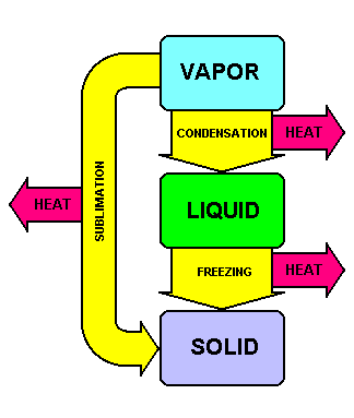 | Wind alone can be a major weather factor for pilots, but when you add in moisture, it gets even more complex. You remember that water can exist in three different states: liquid, solid and gas. We use the term "water vapor" for the gaseous form of water in the air. The processes by which water changes state all involve the addition or production of heat. Heat must be added to achieve melting or evaporation. It must be removed for freezing or condensation. Sublimation is the term for both changing from solid to gas and gas to solid directly, bypassing the liquid stage. Heat must be added if the change is from solid to gas and it must be removed for changing from gas to solid. With respect to weather, liquid water can be suspended in small drops, as in clouds or fog. It can be in larger drops as falling rain, or on the surface of objects as dew. Weather's solid forms of water include ice crystals, snow, hail, and frost. |
Earlier we said that air could contain as much as five percent water vapor. The maximum that it can contain depends primarily on its temperature. There are three ways to describe the amount of water vapor in air. Absolute humidity is measured in grams per cubic meter, and is not of much interest to pilots. Relative humidity is expressed as a percent of the maximum water vapor that the air can hold at its current temperature and pressure. Dew point is the temperature to which the air must be cooled for the existing water vapor to equal the maximum that the air can hold. When it reaches that point air is said to be saturated. Another useful term for pilots is "spread", which is the difference between the current temperature and the current dew point.
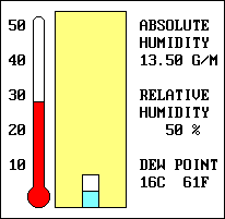 The air in our illustration is shown in yellow for no good reason. Brown might have been a more realistic choice. The little box at the bottom represents our air sample's capacity for water vapor. Note that capacity decreases as the temperature decreases. The actual water vapor content is shown in blue although water vapor is transparent. In our example, the amount of water vapor in our air sample is constant. As the temperature decreases from 28oC to 16oC the relative humidity changes from 50% to 100%. The dew point in this example is 16oC, because that is where the air reaches its saturation point. That is the temperature when the water vapor usually starts to change to liquid or solid. "As air becomes saturated, water vapor begins to condense on the nearest available surface. Some condensation nuclei have an affinity for water and can induce condensation or sublimation even when air is almost but not completely saturated."
(2)
The air in our illustration is shown in yellow for no good reason. Brown might have been a more realistic choice. The little box at the bottom represents our air sample's capacity for water vapor. Note that capacity decreases as the temperature decreases. The actual water vapor content is shown in blue although water vapor is transparent. In our example, the amount of water vapor in our air sample is constant. As the temperature decreases from 28oC to 16oC the relative humidity changes from 50% to 100%. The dew point in this example is 16oC, because that is where the air reaches its saturation point. That is the temperature when the water vapor usually starts to change to liquid or solid. "As air becomes saturated, water vapor begins to condense on the nearest available surface. Some condensation nuclei have an affinity for water and can induce condensation or sublimation even when air is almost but not completely saturated."
(2)
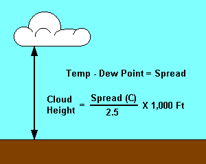 | Air can be cooled in different ways. We have already seen that lifting air reduces its temperature at a rate of 3oC per 1,000 feet. That explains why those puffy white clouds sometimes form at the top of thermals. If you know the spread you can predict the height of cloud bases that are formed by convection. The temperature of the air is decreasing at a rate of 3oC per 1,000 feet, and the dew point is decreasing at a rate of about .5oC per 1,000 feet. (The amount of water vapor that air can hold is affected by pressure as well as temperature, but to a lesser degree.) Thus the temperature and dew point converge at a rate of 2.5oC per 1,000 feet. If the spread is 10oC then the cloud bases will be at approximately 4,000 feet above the surface. (10 / 2.5 = 4.) |
A cloud at the surface is called fog. Fog is likely when a small temperature-dew point spread exists. There are five types of fog with which pilots are expected to be familiar.
| Radiation Fog | Radiation fog forms on clear cool nights when radiation cools the earth's surface and lower levels of air. The fog, sometimes called ground fog, is usually shallow and burns off soon after sunrise. |
| Upslope Fog | The result of moist, stable air moving up sloping terrain. The air cools at the same rate as unstable air that is lifted, and fog forms when the air reaches its dew point. |
| Advection Fog | Advection fog forms when moist air moves over colder ground or water. It typically forms offshore over cold water and can be blown inland. If the wind is more than 15 knots, the fog may be lifted into a layer of cloud. Advection fog is usually more extensive and more persistent than radiation fog. |
| Precipitation Fog | Caused by rain falling through cold air. Evaporation increases the water vapor content of the air until it reaches saturation. It is usually associated with a warm front. |
| Steam Fog | Sometimes called "sea smoke," it forms when cold, dry air passes from land areas over warmer ocean waters. Low-level turbulence and icing may be associated with steam fog. |
Dew and frost occur when water vapor condenses or sublimates directly on a cold surface. Whether it is dew or frost depends on whether the temperature is above or below freezing. Frost must be removed from glider airfoils before flight because its roughness spoils the smooth flow of air, not because it alters the airfoil shape significantly.
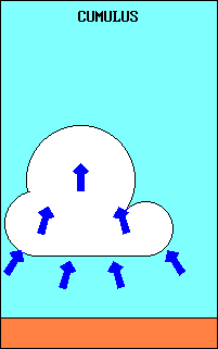
Clouds can be categorized several ways, and for some categories there are clues in the cloud names. "Cumuliform" indicates that the cloud develops vertically. They are associated with unstable air. The "cumulus" cloud at the top of a thermal is a good example. "Stratiform" clouds form in layers or strata and are associated with stable air. The prefix nimbo or the suffix nimbus indicates rain.
Clouds are also divided into four families:
| TYPE | BASE HEIGHT | EXAMPLES |
|---|---|---|
| High Clouds | 16,500' to 45,000' | cirrus, cirrocumulus, cirrostratus |
| Middle Clouds | 6,500' to 23,000' | altostratus, altocumulus, nimbostratus |
| Low Clouds | Up to 6,500' | cumulus, stratus, stratocumulus |
| Extensive Vertical Development | 1,000' to 10,000' | towering cumulus, cumulonimbus |
The type of cloud depends on the stability of the air in which it forms. Some characteristics of air stability are:
Unstable Air
| Stable Air
|
When an air mass stays in one place for a period of time it develops properties characteristic of that area. Air masses that enter the contiguous states typically are cold and dry from the north or warm and moist from the south. Much of the weather we experience occurs at the boundary between two air masses, called a "front". Fronts come in several varieties:
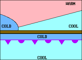
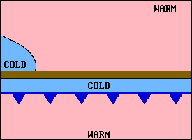 | A cold front is one in which a colder air mass is replacing a warmer one. The upper illustration is an exaggerated cross-section of a cold front. The lower one shows the symbol that would appear on a weather map. A cold front has a steeper leading edge than a warm front and it usually moves much faster. As the wedge of cold air pushes under the retreating warm air it lifts the warm air. If the warm air is moist and unstable violent weather can result. In this simplified description of a cold front one would expect the weather to occur behind the surface location of the front. An examination of actual weather maps often shows most of the weather ahead of the surface location of the front. Sometimes a squall line forms far ahead of the cold front. |
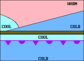
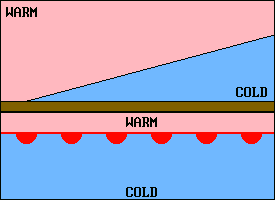 | A warm front is one in which a warm air mass is replacing a colder one. The shallow slope typical of a warm front is shown in the upper illustration and its weather map symbol is shown below. The type of weather associated with a warm front depends on the stability of the warm air, and it usually covers a much larger area than that associated with a cold front. If the temperature of the cold air is below freezing, rain falling from the warm air above may freeze before reaching the surface. "Ice pellets always indicate freezing rain at higher altitude." (2) |
 | In a stationary front, as the name implies, neither air mass is replacing the other. It is convenient to think of air masses as mountains of air, separated by valleys where the front resides. The air circulates around these mountains (highs) in a clockwise direction. The result of that is that the direction and/or speed of the wind always changes across a front. Temperature difference is usually significant and "is one of the most easily recognized discontinuities across a front." (2) After a while differences between adjacent air masses diminish and the front dissipates. The process is called "frontolysis". The name for the generation of a front is "frontogenesis". |
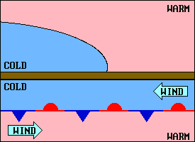
 | Sometimes along stationary or slow moving cold fronts, a frontal wave develops. A typical situation in the U.S. is illustrated here. The wave produces a cold front to the left and a warm front to the right and a low pressure center develops at the peak of the wave. The faster moving cold front may overtake the warm front and produce an occlusion near the low. |
 | In a cold front occlusion the air behind the cold front is colder than the air ahead of the warm front. The weather associated with this system may have characteristics common to both cold and warm fronts, determined by the stability of the air masses. |
 | The warm front occlusion produces weather similar to that produced by the cold front occlusion. It differs in that the air ahead of the warm front is colder than the air behind the cold front. The names are based on the front at the surface. |
Cumulonimbus or thunderstorms are among the most hazardous conditions any pilot can encounter. Since they evolve from cumulus clouds, glider pilots must be alert for them on good soaring days. Hazards associated with thunderstorms include lightning, hail, strong turbulence and wind shear. Three things are required for a thunderstorm to develop:
 A thunderstorm's life consists of three stages:
Thunderstorms that develop on a good soaring day are typically air mass thunderstorms. Their life cycle may be 1-1/2 hours or less. Steady state thunderstorms are usually associated with a weather system such as a front and their mature stage can last much longer. A squall line is a line of thunderstorms that forms ahead of a front, sometimes far ahead. "It often contains severe steady-state thunderstorms and presents the single most intense weather hazard to aircraft."(2) Tornadoes are more likely to occur with steady state thunderstorms.
Hail can occur several miles from the thunderstorm producing it, especially under the anvil. Strong turbulence is indicated by cumulonimbus mamma clouds and roll clouds. "Outside the cloud, shear turbulence has been encountered several thousand feet above and 20 miles laterally from a severe storm. A low level turbulent area is the shear zone between the plow wind and surrounding air."(2)
Obviously gliders should avoid thunderstorms by a wide margin. If caught in one the recommended procedure is to try to maintain a constant attitude at a safe speed. That may be impossible without gyroscopic instruments.
Wind shear is defined as a change in wind speed or direction over a short distance and it can exist in both a horizontal and vertical direction. A thermal is a relatively innocuous example of vertical wind shear. However, sometimes violent descending columns of air called microbursts occur. They are often associated with thunderstorms but can occur other places such as below virga, rain that evaporates before reaching the ground. When the microburst reaches the ground it spreads out, creating strong horizontal wind shear that can be especially devastating for landing aircraft. "The downdrafts can be as strong as 6,000 feet per minute. Horizontal winds near the surface can be as strong as 45 knots resulting in a 90-knot shear (headwind to tailwind change for a traversing aircraft) across the microburst. An individual microburst will seldom last longer than 15 minutes from the time it strikes the ground until dissipation. The horizontal winds continue to increase during the first 5 minutes with the maximum intensity winds lasting approximately 2-4 minutes."(4)
Another place where pilots can expect wind shear is at the top of a ground based inversion when the wind at 2,000 to 4,000 feet AGL is 25 knots or more. Expect significant airspeed variations when passing through this zone either on tow or when descending for landing.
Motorglider pilots should consult their aircraft manuals for information about coping with carburetor ice. All glider pilots could encounter structural icing. Structural icing adds weight to the aircraft, but more importantly, it affects the shape of airfoils and can seriously degrade performance. It can occur in clouds but cloud flying in gliders in the U.S. is rare. Structural icing requires a freezing temperature and visible moisture. That combination is possible when flying below a frontal surface. Raindrops from the warmer air above can become supercooled and freeze on impact with the glider. It is also possible for aerodynamic cooling to lower the temperature of an airfoil below freezing even though the nearby air is slightly above freezing.
© 2005 Jim D. Burch 602-942-2734 jdburch@att.net
To return to table of contents select TOC