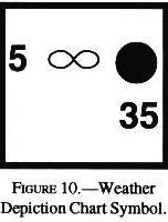
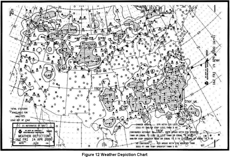
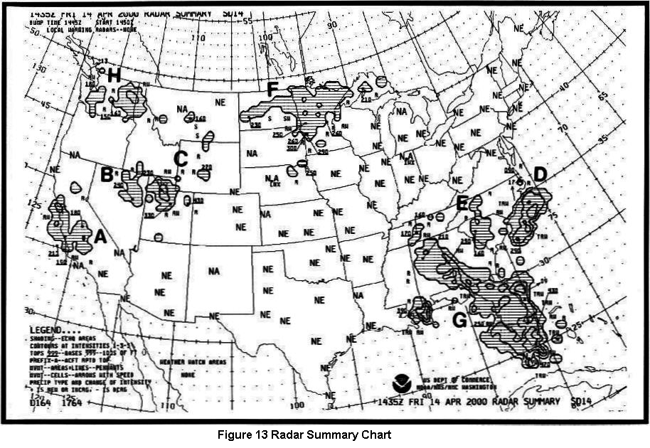
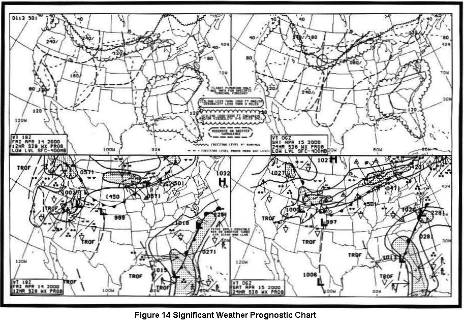
Answer B is Incorrect, Try Again
![]()
Answer B is Incorrect, Try Again
![]()
Answer C is Incorrect, Try Again
| Density Altitude - This altitude is pressure altitude corrected for nonstandard temperature variations. When conditions are standard, pressure altitude and density altitude are the same. Consequently, if the temperature is above standard, the density altitude will be higher than pressure altitude. |
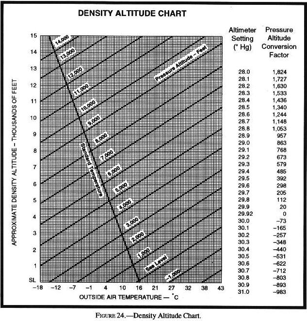
| First, compute the pressure altitude conversion. Find the "Altimeter Setting" and read across to the "Pressure Altitude Conversion Factor" and add it to or subtract it from the airport elevation. Next, locate the outside air temperature on the scale along the bottom of the graph. Draw a line up to the pressure altitude line. Draw a line straight across to the far left side of the graph and read the approximate density altitude. |
| First, compute the pressure altitude conversion. Find the "Altimeter Setting" and read across to the "Pressure Altitude Conversion Factor" and add it to or subtract it from the airport elevation. Next, locate the outside air temperature on the scale along the bottom of the graph. Draw a line up to the pressure altitude line. Draw a line straight across to the far left side of the graph and read the approximate density altitude. |
| First, compute the pressure altitude conversion. Find the "Altimeter Setting" and read across to the "Pressure Altitude Conversion Factor" and add it to or subtract it from the airport elevation. Next, locate the outside air temperature on the scale along the bottom of the graph. Draw a line up to the pressure altitude line. Draw a line straight across to the far left side of the graph and read the approximate density altitude. |
| First, compute the pressure altitude conversion. Find the "Altimeter Setting" and read across to the "Pressure Altitude Conversion Factor" and add it to or subtract it from the airport elevation. Next, locate the outside air temperature on the scale along the bottom of the graph. Draw a line up to the pressure altitude line. Draw a line straight across to the far left side of the graph and read the approximate density altitude. |
| First, compute the pressure altitude conversion. Find the "Altimeter Setting" and read across to the "Pressure Altitude Conversion Factor" and add it to or subtract it from the airport elevation. Next, locate the outside air temperature on the scale along the bottom of the graph. Draw a line up to the pressure altitude line. Draw a line straight across to the far left side of the graph and read the approximate density altitude. |
| Standard sea level pressure is defined as 29.92 in. Hg. at 59oF(15oC). |
| Wind shear is a sudden, drastic change in windspeed and/or direction over a very small area. ..While wind shear can occur at any altitude, low-level wind shear is especially hazardous due to the proximity of an aircraft to the ground. |
| Stable Air: Stratiform clouds and fog; Continuous precipitation; Smooth air; Fair to poor visibility in haze and smoke. |
| Weather involves movement of air and changes of state of water. Air movement ultimately can be traced to heating from the sun. Changes of state of water (evaporation, condensation, melting, freezing, and sublimation) all involve adding or releasing heat. |
| Differences in temperature create differences in pressure. These pressure differences drive a complex system of winds in a never ending attempt to reach equilibrium. |
| An increase in temperature with altitude is defined as an inversion, i.e. lapse rate is inverted. |
| An inversion often develops near the ground on clear, cool nights when wind is light. The ground radiates and cools much faster than the overlying air. |
| A ground based inversion favors poor visibility by trapping fog, smoke, and other restrictions into low levels of the atmosphere. |
| On a hot day, the air becomes "thinner" or lighter, and its density where you are is equivalent to a higher altitude in the standard atmosphere - thus the term "high density altitude." |
| Density altitude simply is the altitude in the standard atmosphere where air density is the same as where you are. |
| Friction between the wind and the terrain surface slows the wind. As frictional force slows the windspeed, Coriolis force decreases. The stronger pressure gradient force turns the wind at an angle to the isobars toward lower pressure. |
| Dew point is the temperature to which air must be cooled to become saturated by the water vapor already present in the air. |
| Temperature largely determines the maximum amount of water vapor air can hold. |
| As air becomes saturated, water vapor begins to condense on the nearest available surface. Some condensation nuclei have an affinity for water and can induce condensation or sublimation even when air is almost but not completely saturated. |
| Evaporation, condensation, sublimation, freezing, and melting are changes of state. Evaporation is the changing of liquid water to invisible water vapor. Condensation is the reverse process. Sublimation is the changing of ice directly to water vapor, or water vapor to ice, bypassing the liquid state in each process. |
| Frost forms in much the same way as dew. The difference is that the dew point of surrounding air must be colder than freezing. Water vapor then sublimates directly as ice crystals or frost rather than condensing as dew. |
| Ice pellets always indicate freezing rain at higher altitude. |
| In a convective current, temperature and dew point converge at about 4.4 degrees F (2.5 degrees C) per 1,000 feet. |
| Unstable Air: Cumuliform clouds; Showery precipitation; Rough air (turbulence); Good visibility, except in blowing obstructions. |
| Unstable Air: Cumuliform clouds; Showery precipitation; Rough air (turbulence); Good visibility, except in blowing obstructions. |
| Since stable air resists convection, clouds in stable air form in horizontal, sheet-like layers or "strata." Thus, within a stable layer, clouds are stratiform. Adiabatic cooling may be by upslope flow; by lifting over cold, more dense air; or by converging winds. |
| If the temperature increases with altitude through a layer - an inversion - the layer is stable and convection is suppressed. |
| Unstable air favors convection. A "cumulus" cloud, meaning "heap," forms in a convective updraft and builds upward. Thus, within an unstable layer, clouds are cumuliform; and the vertical extent of the cloud depends on the depth of the unstable layer. |
| A mass of air in which the temperature decreases rapidly with height favors instability; but, air tends to be stable if the temperature changes little or not at all with altitude. |
| Surface heating or cooling aloft can make the air more unstable; on the other hand, surface cooling or warming aloft often tips the balance toward greater stability. |
| Since stable air resists convection, clouds in stable air form in horizontal, sheet-like layers or "strata." Thus, within a stable layer, clouds are stratiform. Adiabatic cooling may be by upslope flow; by lifting over cold, more dense air; or by converging winds. |
| The prefix nimbo or the suffix nimbus means raincloud. |
| For identification purposes, you need be concerned only with the more basic cloud types, which are divided into four "families." The families are: high clouds, middle clouds, low clouds, and clouds with extensive vertical development. |
| Towering cumulus signifies a relatively deep layer of unstable air. Showers can result from these clouds. Very strong turbulence; some clear icing above the freezing level. |
| Cumulonimbus are the ultimate manifestation of instability. Nearly the entire spectrum of flying hazards are contained in these clouds including violent turbulence. |
| Temperature is one of the most easily recognized discontinuities across a front. |
| Wind always changes across a front. Wind discontinuity may be in direction, in speed, or in both. |
| Stable Air: Stratiform clouds and fog; Continuous precipitation; Smooth air; Fair to poor visibility in haze and smoke. |
| The zone between two different air masses is a frontal zone or front. |
| Wind shear may be associated with either a wind shift or a wind speed gradient at any level in the atmosphere. Three conditions are of special interest - (1) wind shear with a low-level temperature inversion, (2) wind shear in a frontal zone, and (3) clear air turbulence (CAT) at high levels associated with a jet stream or strong circulation. |
| You can be relatively certain of a shear zone in the inversion if you know the wind at 2,000 to 4,000 feet is 25 knots or more. Allow a margin of airspeed above normal climb or approach speed to alleviate danger of a stall in the event of turbulence or sudden change in wind velocity. |
| Two conditions are necessary for structural icing in flight: (1) the aircraft must be flying through visible water such as rain or cloud droplets, and (2) the temperature at the point where the moisture strikes the aircraft must be 0 degrees C or colder. Aerodynamic cooling can lower temperature of an airfoil to 0 degrees C even though the ambient temperature is a few degrees warmer. |
| A condition favorable for rapid accumulation of clear icing is freezing rain below a frontal surface. Rain forms above the frontal surface at temperatures warmer than freezing. Subsequently, it falls through air at temperatures below freezing and becomes supercooled. The supercooled drops freeze on impact with an aircraft surface. |
| Precipitation beginning to fall from the cloud base is your signal that a downdraft has developed and a cell has entered the mature stage. |
| For a thunderstorm to form, the air must have (1) sufficient water vapor, (2) an unstable lapse rate, and (3) an initial boost (lifting) to start the storm process in motion. |
| For a thunderstorm to form, the air must have (1) sufficient water vapor, (2) an unstable lapse rate, and (3) an initial boost (lifting) to start the storm process in motion. |
| Downdrafts characterize the dissipating stage of the thunderstorm cell and the storm dies rapidly. |
| All thunderstorm hazards reach their greatest intensity during the mature stage. |
| A squall line is a non-frontal, narrow band of active thunderstorms. Often it develops ahead of a cold front in moist, unstable air, but it may develop in unstable air far removed from any front. It often contains severe steady-state thunderstorms and presents the single most intense weather hazard to aircraft. |
| A squall line is a non-frontal, narrow band of active thunderstorms. Often it develops ahead of a cold front in moist, unstable air, but it may develop in unstable air far removed from any front. It often contains severe steady-state thunderstorms and presents the single most intense weather hazard to aircraft. |
| Outside the cloud, shear turbulence has been encountered several thousand feet above and 20 miles laterally from a severe storm. A low level turbulent area is the shear zone between the plow wind and surrounding air. |
| During thunderstorm penetration: Don't change power settings; maintain settings for reduced airspeed. Do maintain a constant attitude; ... Maneuvers in trying to maintain constant altitude increase stresses on the aircraft. |
| The key feature of the cumulus stage is an updraft. |
| Conditions favorable for radiation fog are clear sky, little or no wind, and a small temperature-dew point spread (high relative humidity). |
| Fog is a surface based cloud composed of either water droplets or ice crystals. Small temperature-dew point spread is essential for fog to form. |
| Advection fog forms when moist air moves over colder ground or water. It is common along coastal areas... Wind much stronger than 15 knots lifts the fog into a layer of low stratus or stratocumulus. This fog frequently forms offshore as a result of cold water and then is carried inland by the wind. |
| Upslope fog forms as a result of moist, stable air being cooled adiabatically as it moves up sloping terrain. Once the upslope wind ceases, the fog dissipates. |
| Steam fog, often called "sea smoke," forms in winter when cold, dry air passes from land areas over comparatively warm ocean waters. Low level turbulence can occur and icing can become hazardous. |
| Outside the cloud, shear turbulence has been encountered several thousand feet above and 20 miles laterally from a severe storm. A low level turbulent area is the shear zone between the plow wind and surrounding air. |
| Thunder is caused by lightning. Unless there is lightning there can be no "thunder" storm. |
| When lifted, unsaturated air cools at a rate of 5.4oF per 1,000 feet and the dewpoint temperature decreases at a rate of 1oF per 1,000 feet. This results in a convergence of temperature and dewpoint at a rate of 4.4oF. |
| In the Northern Hemisphere, this flow of air from areas of high to low pressure is deflected to the right: producing a clockwise circulation around an area of high pressure...also known as anti-cyclonic circulation. The opposite is true of low-pressure areas; the air flows toward a low and is deflected to create a counter-clockwise or cyclonic circulation. |
| The Coriolis force deflects air to the right in the Northern Hemisphere, causing it to follow a curved path instead of a straight line. |
| High-pressure systems are generally areas of dry, stable, descending air. Good weather is typically associated with high-pressure systems for this reason. Conversely, air flows into a low-pressure area to replace rising air...bad weather is commonly associated with areas of low pressure. |
| For a thunderstorm to form, the air must have (1) sufficient water vapor, (2) an unstable lapse rate, and (3) an initial boost (lifting) to start the storm process in motion. |
| This decrease of temperature with altitude is defined as lapse rate. The average decrease of temperature - average lapse rate - in the troposphere is 2 degrees C per 1,000 feet. |
| Weather involves movement of air and changes of state of water. Air movement ultimately can be traced to heating from the sun. Changes of state of water (evaporation, condensation, melting, freezing, and sublimation) all involve adding or releasing heat. |
| An inversion often develops near the ground on clear, cool nights when wind is light. The ground radiates and cools much faster than the overlying air. |
| The Standard Atmosphere: Mean Sea Level - Pressure 29.92 in. Hg or 1013.2 millibars; Temperature 15.0oC or 59oF. |
| To compute density altitude, set your altimeter at 29.92 inches or 1013.2 millibars and read pressure altitude from your altimeter. Read outside air temperature and then use your flight computer to get density altitude. |
| The instant air begins moving, Coriolis force deflects it to the right. Soon the wind is deflected a full 90 degrees and is parallel to the isobars or contours. At this time, Coriolis force exactly balances pressure gradient force. |
| A low or trough is an area of rising air. Rising air is conducive to cloudiness and precipitation; thus we have the general association of low pressure - bad weather. |
| The Coriolis force affects the paths of aircraft; missiles; flying birds; ocean currents; and, most important to the study of weather, air currents. The force deflects air to the right in the Northern Hemisphere, and to the left in the Southern hemisphere. |
| The closer the spacing of isobars, the stronger is the pressure gradient force. The stronger the pressure gradient force, the stronger is the wind. |
| As winds try to blow inward toward the center of low pressure, they are also deflected to the right. Thus, the wind around a low is counterclockwise. The low pressure and its wind system is a cyclone. |
| Differences in temperature create differences in pressure. These pressure differences drive a complex system of winds in a never ending attempt to reach equilibrium. |
| Shallow frontal surfaces tend to give extensive cloudiness with large precipitation areas. If temperature of the cold air near the surface is below freezing, precipitation falls as freezing rain or ice pellets. |
| Some rain may reach the ground or it may evaporate as it falls into drier air. "Virga" - streamers of precipitation trailing beneath clouds but evaporating before reaching the ground. |
| Evaporation, condensation, sublimation, freezing, and melting are changes of state. Evaporation is the changing of liquid water to invisible water vapor. Condensation is the reverse process. Sublimation is the changing of ice directly to water vapor, or water vapor to ice, bypassing the liquid state in each process. |
| Ice pellets always indicate freezing rain at higher altitude. |
| The difference between air temperature and dew point temperature is popularly called the "spread." As spread becomes less, relative humidity increases, and it is 100% when temperature and dew point are the same. |
| In a convective current, temperature and dew point converge at about 4.4 degrees F (2.5 degrees C) per 1,000 feet. |
| Since stable air resists convection, clouds in stable air form in horizontal, sheet-like layers or "strata." Thus, within a stable layer, clouds are stratiform. Adiabatic cooling may be by upslope flow; by lifting over cold, more dense air; or by converging winds. |
| Whether the air is stable or unstable within a layer largely determines cloud structure. |
| Whether the air is stable or unstable within a layer largely determines cloud structure. |
| For a thunderstorm to form, the air must have (1) sufficient water vapor, (2) an unstable lapse rate, and (3) an initial boost (lifting) to start the storm process in motion. |
| Stable Air: Stratiform clouds and fog; Continuous precipitation; Smooth air; Fair to poor visibility in haze and smoke. |
| A mass of air in which the temperature decreases rapidly with height favors instability; but, air tends to be stable if the temperature changes little or not at all with altitude. |
| Surface heating or cooling aloft can make the air more unstable; on the other hand, surface cooling or warming aloft often tips the balance toward greater stability. |
| Surface heating or cooling aloft can make the air more unstable; on the other hand, surface cooling or warming aloft often tips the balance toward greater stability. |
| Towering cumulus signifies a relatively deep layer of unstable air. Showers can result from these clouds. Very strong turbulence; some clear icing above the freezing level. |
| Since stable air resists convection, clouds in stable air form in horizontal, sheet-like layers or "strata." Thus, within a stable layer, clouds are stratiform. Adiabatic cooling may be by upslope flow; by lifting over cold, more dense air; or by converging winds. |
| Cool air moving over a warm surface is heated from below, generating instability. |
| Unstable Air: Cumuliform clouds; Showery precipitation; Rough air (turbulence); Good visibility, except in blowing obstructions. |
| In the cold front occlusion, the coldest air is under the cold front. When it overtakes the warm front, it lifts the warm front aloft; and the cold air replaces cool air at the surface. |
| Wind shear may be associated with either a wind shift or a wind speed gradient at any level in the atmosphere. Three conditions are of special interest - (1) wind shear with a low-level temperature inversion, (2) wind shear in a frontal zone, and (3) clear air turbulence (CAT) at high levels associated with a jet stream or strong circulation. |
| Wind shear may be associated with either a wind shift or a wind speed gradient at any level in the atmosphere. Three conditions are of special interest - (1) wind shear with a low-level temperature inversion, (2) wind shear in a frontal zone, and (3) clear air turbulence (CAT) at high levels associated with a jet stream or strong circulation. |
| A condition favorable for rapid accumulation of clear icing is freezing rain below a frontal surface. Rain forms above the frontal surface at temperatures warmer than freezing. Subsequently, it falls through air at temperatures below freezing and becomes supercooled. The supercooled drops freeze on impact with an aircraft surface. |
| A squall line is a non-frontal, narrow band of active thunderstorms. Often it develops ahead of a cold front in moist, unstable air, but it may develop in unstable air far removed from any front. It often contains severe steady-state thunderstorms and presents the single most intense weather hazard to aircraft. |
| Outside the cloud, shear turbulence has been encountered several thousand feet above and 20 miles laterally from a severe storm. A low level turbulent area is the shear zone between the plow wind and surrounding air. |
| A squall line is a non-frontal, narrow band of active thunderstorms. Often it develops ahead of a cold front in moist, unstable air, but it may develop in unstable air far removed from any front. It often contains severe steady-state thunderstorms and presents the single most intense weather hazard to aircraft. |
| Precipitation beginning to fall from the cloud base is your signal that a downdraft has developed and a cell has entered the mature stage. |
| The roll cloud is most prevalent with cold frontal or squall line thunderstorms and signifies an extremely turbulent zone. |
| The key feature of the cumulus stage is an updraft. |
| Precipitation beginning to fall from the cloud base is your signal that a downdraft has developed and a cell has entered the mature stage. |
| You should anticipate possible hail with any thunderstorm, especially beneath the anvil of a large cumulonimbus. |
| Hail has been observed in clear air several miles from the parent thunderstorm. |
| Downdrafts characterize the dissipating stage of the thunderstorm cell and the storm dies rapidly. |
| Advection fog forms when moist air moves over colder ground or water. It is common along coastal areas... Wind much stronger than 15 knots lifts the fog into a layer of low stratus or stratocumulus. This fog frequently forms offshore as a result of cold water and then is carried inland by the wind. |
| Advection fog is usually more extensive and much more persistent than radiation fog. Advection fog can move in rapidly regardless of the time of day or night. |
| Advection fog forms when moist air moves over colder ground or water. It is common along coastal areas... Wind much stronger than 15 knots lifts the fog into a layer of low stratus or stratocumulus. This fog frequently forms offshore as a result of cold water and then is carried inland by the wind. |
| Advection fog forms when moist air moves over colder ground or water. It is common along coastal areas... Wind much stronger than 15 knots lifts the fog into a layer of low stratus or stratocumulus. This fog frequently forms offshore as a result of cold water and then is carried inland by the wind. |
| When relatively warm rain or drizzle falls through cool air, evaporation from the precipitation saturates the cool air and forms fog. It is most commonly associated with warm fronts, but can occur with slow moving cold fronts and with stationary fronts. |
| When relatively warm rain or drizzle falls through cool air, evaporation from the precipitation saturates the cool air and forms fog. It is most commonly associated with warm fronts, but can occur with slow moving cold fronts and with stationary fronts. |
| An abrupt change in temperature lapse rate characterizes the tropopause. |
| Cool air must sink to force warm air upward in thermals. Therefore, thermals and downdrafts coexist side by side. The net upward displacement of air must equal the net downward displacement. Fast rising thermals generally cover a small percentage of a convective area while slower downdrafts predominate over the remaining greater portion. |
| Cool air must sink to force warm air upward in thermals. Therefore, thermals and downdrafts coexist side by side. The net upward displacement of air must equal the net downward displacement. Fast rising thermals generally cover a small percentage of a convective area while slower downdrafts predominate over the remaining greater portion. |
| Cool air must sink to force warm air upward in thermals. Therefore, thermals and downdrafts coexist side by side. The net upward displacement of air must equal the net downward displacement. Fast rising thermals generally cover a small percentage of a convective area while slower downdrafts predominate over the remaining greater portion. |
| Locate the outside air temperature at the bottom of the chart and draw a vertical line until it intersects with the pressure altitude. From where the temperature and pressure altitude lines intersect, draw a straight line to the left to determine the density altitude. |
| Since most weather occurs in the troposphere and since most flying is in the troposphere and stratosphere, we restrict our discussions mostly to these two layers. |
| This decrease of temperature with altitude is defined as lapse rate. The average decrease of temperature - average lapse rate - in the troposphere is 2 degrees C per 1,000 feet. |
| An inversion often develops near the ground on clear, cool nights when wind is light. The ground radiates and cools much faster than the overlying air. |
| The amount of solar energy received by any region varies with time of day, with seasons, and with latitude. These differences in solar energy create temperature variations. These temperature variations create forces that drive the atmosphere in its endless motions. |
| At a specified indicated airspeed, your true airspeed and your groundspeed increase proportionally as density altitude becomes higher. |
| Within the lower few thousand feet of the troposphere, pressure decreases roughly one inch for each 1,000 feet increase in altitude. |
| The winds are clockwise around highs and counterclockwise around lows. |
| A low or trough is an area of rising air. Rising air is conducive to cloudiness and precipitation; thus we have the general association of low pressure - bad weather. |
| Differences in temperature create differences in pressure. These pressure differences drive a complex system of winds in a never ending attempt to reach equilibrium. |
| The difference between air temperature and dew point temperature is popularly called the "spread." As spread becomes less, relative humidity increases, and it is 100% when temperature and dew point are the same. |
| Some rain may reach the ground or it may evaporate as it falls into drier air. "Virga" - streamers of precipitation trailing beneath clouds but evaporating before reaching the ground. |
| Ice pellets always indicate freezing rain at higher altitude. |
| In a convective current, temperature and dew point converge at about 4.4 degrees F (2.5 degrees C) per 1,000 feet. |
| A mass of air in which the temperature decreases rapidly with height favors instability; but, air tends to be stable if the temperature changes little or not at all with altitude. |
| Since stable air resists convection, clouds in stable air form in horizontal, sheet-like layers or "strata." Thus, within a stable layer, clouds are stratiform. Adiabatic cooling may be by upslope flow; by lifting over cold, more dense air; or by converging winds. |
| Nimbostratus is a gray or dark massive cloud layer, diffused by more or less continuous rain, snow, or ice pellets. Very little turbulence, but can pose a serious icing problem if temperatures are near or below freezing. |
| Unstable Air: Cumuliform clouds; Showery precipitation; Rough air (turbulence); Good visibility, except in blowing obstructions. |
| Surface heating or cooling aloft can make the air more unstable; on the other hand, surface cooling or warming aloft often tips the balance toward greater stability. |
| Cool air moving over a warm surface is heated from below, generating instability. |
| Unstable Air: Cumuliform clouds; Showery precipitation; Rough air (turbulence); Good visibility, except in blowing obstructions. |
| A temperature inversion forms near the surface on a clear night with calm or light surface wind. Wind just above the inversion may be relatively strong. A wind shear zone develops between the calm and the stronger winds above. Eddies in the shear zone cause airspeed fluctuations as an aircraft climbs or descends through the inversion. |
| A temperature inversion forms near the surface on a clear night with calm or light surface wind. Wind just above the inversion may be relatively strong. A wind shear zone develops between the calm and the stronger winds above. Eddies in the shear zone cause airspeed fluctuations as an aircraft climbs or descends through the inversion. |
| When an aircraft enters the heavy water concentrations found in cumuliform clouds, the large drops break and spread rapidly over the leading edge of the airfoil forming a film of water. If temperatures are freezing or colder, the water freezes quickly to form a solid sheet of clear ice. |
| Two conditions are necessary for structural icing in flight: (1) the aircraft must be flying through visible water such as rain or cloud droplets, and (2) the temperature at the point where the moisture strikes the aircraft must be 0 degrees C or colder. Aerodynamic cooling can lower temperature of an airfoil to 0 degrees C even though the ambient temperature is a few degrees warmer. |
| Precipitation beginning to fall from the cloud base is your signal that a downdraft has developed and a cell has entered the mature stage. |
| For a thunderstorm to form, the air must have (1) sufficient water vapor, (2) an unstable lapse rate, and (3) an initial boost (lifting) to start the storm process in motion. |
| The key feature of the cumulus stage is an updraft. |
| Hail has been observed in clear air several miles from the parent thunderstorm. |
| A squall line is a non-frontal, narrow band of active thunderstorms. Often it develops ahead of a cold front in moist, unstable air, but it may develop in unstable air far removed from any front. It often contains severe steady-state thunderstorms and presents the single most intense weather hazard to aircraft. |
| Conditions favorable for radiation fog are clear sky, little or no wind, and a small temperature-dew point spread (high relative humidity). |
| Advection fog is usually more extensive and much more persistent than radiation fog. Advection fog can move in rapidly regardless of the time of day or night. |
| Advection fog forms when moist air moves over colder ground or water. It is common along coastal areas... Wind much stronger than 15 knots lifts the fog into a layer of low stratus or stratocumulus. This fog frequently forms offshore as a result of cold water and then is carried inland by the wind. |
| Fog is a surface based cloud composed of either water droplets or ice crystals. Small temperature-dew point spread is essential for fog to form. |
| When relatively warm rain or drizzle falls through cool air, evaporation from the precipitation saturates the cool air and forms fog. It is most commonly associated with warm fronts, but can occur with slow moving cold fronts and with stationary fronts. |
| Cool air must sink to force warm air upward in thermals. Therefore, thermals and downdrafts coexist side by side. The net upward displacement of air must equal the net downward displacement. Fast rising thermals generally cover a small percentage of a convective area while slower downdrafts predominate over the remaining greater portion. |
| An individual microburst will seldom last longer than 15 minutes from the time it strikes the ground until dissipation. The horizontal winds continue to increase during the first 5 minutes with the maximum intensity winds lasting approximately 2-4 minutes. |
| The downdrafts can be as strong as 6,000 feet per minute. Horizontal winds near the surface can be as strong as 45 knots resulting in a 90 knot shear (headwind to tailwind change for a traversing aircraft) across the microburst. |
| An individual microburst will seldom last longer than 15 minutes from the time it strikes the ground until dissipation. The horizontal winds continue to increase during the first 5 minutes with the maximum intensity winds lasting approximately 2-4 minutes. |