Answer B is Incorrect, Try Again
![]()
Answer B is Incorrect, Try Again
![]()
Answer C is Incorrect, Try Again
| Land absorbs and radiates heat faster than water. This creates a temperature and pressure difference over the two kinds of surfaces. On sunny days, the cool, dense air over the ocean moves inward and forces the warmer coastal air to rise. |
| Solving for Time - Rotate the computer disc until the speed index is located directly under (the speed). The answer is read from the middle scale, directly below (the distance). |
| Solving for Time - Rotate the computer disc until the speed index is located directly under (the speed). The answer is read from the middle scale, directly below (the distance). |
| UTC is the time at the 0o line of longitude. To convert to this time, a pilot should do the following: Eastern Standard Time - Add 5 hours; Central Standard Time - Add 6 hours; Mountain Standard Time - Add 7 hours; Pacific Standard Time - Add 8 hours. For daylight saving time, 1 hour should be subtracted from the calculated times. |
| UTC is the time at the 0o line of longitude. To convert to this time, a pilot should do the following: Eastern Standard Time - Add 5 hours; Central Standard Time - Add 6 hours; Mountain Standard Time - Add 7 hours; Pacific Standard Time - Add 8 hours. For daylight saving time, 1 hour should be subtracted from the calculated times. |
| UTC is the time at the 0o line of longitude. To convert to this time, a pilot should do the following: Eastern Standard Time - Add 5 hours; Central Standard Time - Add 6 hours; Mountain Standard Time - Add 7 hours; Pacific Standard Time - Add 8 hours. For daylight saving time, 1 hour should be subtracted from the calculated times. |
| UTC is the time at the 0o line of longitude. To convert to this time, a pilot should do the following: Eastern Standard Time - Add 5 hours; Central Standard Time - Add 6 hours; Mountain Standard Time - Add 7 hours; Pacific Standard Time - Add 8 hours. For daylight saving time, 1 hour should be subtracted from the calculated times. |
| Circles parallel to the Equator (lines running east and west) are parallels of latitude. They are used to measure degrees of latitude north and south of the Equator. Meridians of longitude are drawn from the North Pole to the South Pole and are at right angles to the Equator. The "Prime Meridian" which passes through Greenwich, England, is used as the zero line from which measurements are made in degrees east and west to 180o. |
| UTC is the time at the 0o line of longitude. To convert to this time, a pilot should do the following: Eastern Standard Time - Add 5 hours; Central Standard Time - Add 6 hours; Mountain Standard Time - Add 7 hours; Pacific Standard Time - Add 8 hours. For daylight saving time, 1 hour should be subtracted from the calculated times. |
|
|
|
| True direction must be converted to magnetic direction...by adding or subtracting the variation which is indicated by the nearest isogonic line on the chart. |
| True direction must be converted to magnetic direction...by adding or subtracting the variation which is indicated by the nearest isogonic line on the chart. |
| Crests of the standing waves may be marked by stationary, lens-shaped clouds known as "standing lenticular" clouds. They form in the updraft and dissipate in the downdraft, so they do not move as the wind blows through them. |
| Crests of the standing waves may be marked by stationary, lens-shaped clouds known as "standing lenticular" clouds. They form in the updraft and dissipate in the downdraft, so they do not move as the wind blows through them. |
| MOUNTAIN WAVE: When stable air crosses a mountain barrier ... air flowing up the windward side is relatively smooth. Wind flow across the barrier is laminar - that is, it tend to flow in layers. The barrier may set up waves in these layers ... The waves remain nearly stationary while the wind blows rapidly through them. .. The wave pattern may extend 100 miles or more downwind from the barrier. |
| Wind blowing toward hills or ridges flows upward, over, and around the abrupt rises in terrain. The upward moving air creates lift which is sometimes excellent for soaring. |
| Since thermals depend on solar heating, thermal soaring is restricted virtually to daylight hours with considerable sunshine. |
| Stay out of the "eye" of the vortex. |
| Thermal streeting may occur either in clear air or with convective clouds... A pilot can soar under a cloud street maintaining generally continuous flight and seldom, if ever, have to circle. |
| When heating is slow or intermittent, a "bubble" may be pinched off and forced upward; after an interval ranging from a few minutes to an hour or more, another bubble forms and rises... Birds may be climbing in a bubble, but an aircraft attempting to enter the thermal at a lower altitude may find no lift. |
| Cumulus clouds are positive signs of thermals, but thermals grow and die... The warmest and most rapidly rising air is in the center of the thermal. Therefore, the cloud base will be highest in the center giving a concave shape to the cloud base. |
| Always approach the whirling vortex at an altitude 500 feet or more above the ground... Circle on the outside of the dust devil against the direction of rotation. |
| Surface winds must converge to feed a rising thermal; so when you sight a likely spot for a thermal, look for dust or smoke movement near the surface. If you can see dust or smoke "streamers" from two or more sources converging on the spot, you have chosen wisely. |
| If a rocky knob protrudes above a grassy plain, the most likely area of thermals is over the eastern slope in the forenoon and over the western slope in the afternoon. |
| Caused by the heating of land on warm, sunny days, the sea breeze usually begins during early forenoon, reaches a maximum during the afternoon, and subsides around dusk after the land has cooled. The leading edge of the cool sea breeze forces warmer air inland to rise. |
| Caused by the heating of land on warm, sunny days, the sea breeze usually begins during early forenoon, reaches a maximum during the afternoon, and subsides around dusk after the land has cooled. The leading edge of the cool sea breeze forces warmer air inland to rise. |
| Billowy fair weather cumulus clouds,... are signposts in the sky indicating convective turbulence. The cloud top usually marks the approximate upper limit of the convective current. |
| Billowy fair weather cumulus clouds,... are signposts in the sky indicating convective turbulence. The cloud top usually marks the approximate upper limit of the convective current. |
 FAR 91.119(b) Over any congested area... an altitude of 1,000 feet above the highest obstacle within a horizontal radius of 2,000 feet. FAR 91.119(b) Over any congested area... an altitude of 1,000 feet above the highest obstacle within a horizontal radius of 2,000 feet.
|
|
|
FAR 91.119(b) Over any congested area... an altitude of 1,000 feet above the highest obstacle within a horizontal radius of 2,000 feet.
|
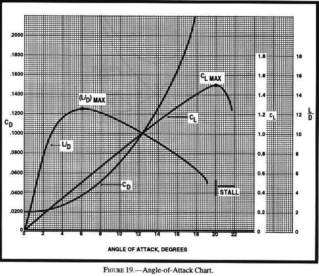
| If maximum distance over the ground is desired, the airspeed for best L/D should be used. When gliding into a headwind, distance will be achieved by adding approximately one-half of the estimated headwind velocity to the best L/D speed. |
| To set up miles traveled versus feet of altitude lost, set the speed index under the known glide ratio. With this ratio set on the computer, any distance on the outer scale can be related to altitude loss on the inner scale. |
| To set up miles traveled versus feet of altitude lost, set the speed index under the known glide ratio. With this ratio set on the computer, any distance on the outer scale can be related to altitude loss on the inner scale. |
| To set up miles traveled versus feet of altitude lost, set the speed index under the known glide ratio. With this ratio set on the computer, any distance on the outer scale can be related to altitude loss on the inner scale. |
| To set up miles traveled versus feet of altitude lost, set the speed index under the known glide ratio. With this ratio set on the computer, any distance on the outer scale can be related to altitude loss on the inner scale. |
| To set up miles traveled versus feet of altitude lost, set the speed index under the known glide ratio. With this ratio set on the computer, any distance on the outer scale can be related to altitude loss on the inner scale. |
| If maximum distance over the ground is desired, the airspeed for best L/D should be used. When gliding into a headwind, distance will be achieved by adding approximately one-half of the estimated headwind velocity to the best L/D speed. |
| To set up miles traveled versus feet of altitude lost, set the speed index under the known glide ratio. With this ratio set on the computer, any distance on the outer scale can be related to altitude loss on the inner scale. |
| If the aircraft is operated for hire over water and beyond power-off gliding distance from shore, approved flotation gear readily available to each occupant and at least one pyrotechnic signaling device. |
| The all-important L/D, or glide ratio, never changes in relation to the airmass, because L/D is determined by the design of the sailplane. Glide angle with respect to the ground, however, reflects the direction and velocity of the airmass in which the sailplane flies. |
| ..flying a faster airspeed as the headwind increases will result in the greatest distance over the ground...add half the headwind component to the best L/D for the maximum distance. |
| ..flying a faster airspeed as the headwind increases will result in the greatest distance over the ground...add half the headwind component to the best L/D for the maximum distance. |
| ..flying a faster airspeed as the headwind increases will result in the greatest distance over the ground...add half the headwind component to the best L/D for the maximum distance. |
| ..flying a faster airspeed as the headwind increases will result in the greatest distance over the ground...add half the headwind component to the best L/D for the maximum distance. |
| The best air masses for thermals are those with cool air aloft, with conditions dry enough to allow the sun's heating at the surface...these conditions are usually found after the passage of a cold front. |
| The weather requirements for wave soaring include sufficient wind and a proper stability profile. Wind speed should be at least 15 to 20 knots at mountaintop level with increasing winds above. |
| The first glider in a thermal establishes the direction of turn and all other gliders joining the thermal should turn in the same direction. |
| Just as the flow is deflected upward on the windward side of a ridge, it is deflected downward on the lee side...up to 2,000 fpm or more. |
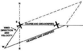
| Because meridians converge toward the poles, course measurement should be taken at a meridian near the midpoint of the course rather than at the point of departure. The course measured on the chart is known as the true course. This is the direction measured by reference to a meridian or true north. |
|
|
| Standing lenticular altocumulus clouds are formed on the crests of waves created by barriers to wind flow. The presence of these clouds is a good indication of very strong turbulence and should be avoided. |
| When approaching mountains from the leeward side during strong winds, ... Climb to an altitude of 3,000 to 5,000 feet above the mountain tops before attempting to cross. The best procedure is to approach a ridge at a 45 degree angle to enable a rapid retreat to calmer air. |
| Turbulence is most frequent and most severe in the standing rotors just beneath the wave crests at or below the mountain-top levels. |
| Convective currents are most active on warm summer afternoons when winds are light. |
| When approaching mountains from the leeward side during strong winds, ... Climb to an altitude of 3,000 to 5,000 feet above the mountain tops before attempting to cross. The best procedure is to approach a ridge at a 45 degree angle to enable a rapid retreat to calmer air. |
| Caused by the heating of land on warm, sunny days, the sea breeze usually begins during early forenoon, reaches a maximum during the afternoon, and subsides around dusk after the land has cooled. The leading edge of the cool sea breeze forces warmer air inland to rise. |
| A surface wind in excess of 10 knots usually means stronger winds aloft resulting in vertical wind shear. This shear causes thermals to lean noticeably. |
| VHF Direction Finder: The equipment consists of a directional antenna system and a VHF radio receiver. The VHF/DF receiver display indicates the magnetic direction of the aircraft from the ground station each time the aircraft transmits. |
|
|
|
|
FAR 91.119(b) Over any congested area... an altitude of 1,000 feet above the highest obstacle within a horizontal radius of 2,000 feet.
|
| ..flying a faster airspeed as the headwind increases will result in the greatest distance over the ground...add half the headwind component to the best L/D for the maximum distance. |
| The first glider in a thermal establishes the direction of turn and all other gliders joining the thermal should turn in the same direction. |
| The all-important L/D, or glide ratio, never changes in relation to the airmass, because L/D is determined by the design of the sailplane. Glide angle with respect to the ground, however, reflects the direction and velocity of the airmass in which the sailplane flies. |
| It is advisable to slow the sailplane to minimum sink airspeed while passing through lift, even if a decision is made not to circle. |
| Circles parallel to the Equator (lines running east and west) are parallels of latitude. They are used to measure degrees of latitude north and south of the Equator. Meridians of longitude are drawn from the North Pole to the South Pole and are at right angles to the Equator. The "Prime Meridian" which passes through Greenwich, England, is used as the zero line from which measurements are made in degrees east and west to 180o. |
|
|
| To find the distance flown in a given time, multiply groundspeed by time. |
| When approaching mountains from the leeward side during strong winds, ... Climb to an altitude of 3,000 to 5,000 feet above the mountain tops before attempting to cross. The best procedure is to approach a ridge at a 45 degree angle to enable a rapid retreat to calmer air. |
| Crests of the standing waves may be marked by stationary, lens-shaped clouds known as "standing lenticular" clouds. They form in the updraft and dissipate in the downdraft, so they do not move as the wind blows through them. |
| In the central and eastern United States, the most favorable weather for cross-country soaring occurs behind a cold front. |
| A strong mountain wave requires: 1. Marked stability in the airstream disturbed by the mountains. 2. Wind speed at the level of the summit should exceed a minimum which varies from 15 to 25 knots. 3. Wind direction should be within 30 degrees normal to the range. |
| When approaching mountains from the leeward side during strong winds, ... Climb to an altitude of 3,000 to 5,000 feet above the mountain tops before attempting to cross. The best procedure is to approach a ridge at a 45 degree angle to enable a rapid retreat to calmer air. |
| Turbulence is most frequent and most severe in the standing rotors just beneath the wave crests at or below the mountain-top levels. |
| Stay out of the "eye" of the vortex. |
|
|